Serre Chevalier
-
29 Via Ferrata Le Rocher Blanc, Serre Chevalier, Saint Chaffrey, Hautes-Alpes, France
Via Ferrata Le Rocher Blanc, Serre Chevalier, Saint Chaffrey
Passerelle Pont de singe Echelle Tyrolienne 0 0 0 0 Caractéristiques
2 Via ferrata facile l'une à côté de l'autre. Elles sont accessible par le téléphérique! Tu peux monter à pied, mais compte 4h de marche pour arriver aux via.
Conseils ViaFerrata
Attention aux chutes de pierres et contacte les remontées mécaniques pour savoir si le téléphérique est ouvert.
Tu es dans un environnement de haute montagne: chaussures de montagne, lunettes de soleil performante, crème solaire, veste imperméable et qui tient chaud en cas de pépin avec un petit truc à manger en cas de creux. Tu peux laisser Killian Jornet aller en basket et short!
Si tu aimes le VTT, tu peux prendre ton vélo et faire la descente en deux roues. C'est très sympa.
Cotation
Physique Voie gauche: 2
Voie droite : 1Gaz Voie gauche: 2
Voie droite : 1Type Haute-Montagne: 1 Technique Voie gauche: 1
Voie droite : 1Evaluation Voie gauche: Difficile
Voie droite : Peu DifficileInformation
Office du Tourisme de Serre Chevalier
Longueur & Altitudes
Départ : 2'370 m
Dénivelé: 105 m
Sommet: 2'475 mCoordonnée GPS du départ
Période
Fin juin/début juillet à la fin août avec l'option téléphérique.
Horaire
Approche, sans l'option téléphérique: 4h
Approche, avec l'option le téléphérique: 20 min
Via ferrata : 1h30 - 2h00
Retour : 30 minPar la route
Direction Serre-Chavalier. La via ferrata se trouve sur la commune de ST-Chaffrey, à côté du départ du téléphérique.
Tu peux également partir de Briançon, mais il te faudra 1h30 de marche pour arriver à la via depuis l'arrivée du télécabine Prorel.
Par le Train
Voir avec la S.N.C.F .
Accès
Le téléphérique part toutes les 15 minutes environ et grimpe à 2'480 m.
A l'arrivée du descends la crête sur la gauche jusqu'au col. Ensuite tu grimpottes en direction du Rocher Blanc. Dès que tu vois le signal via ferrata tu y es. Si tu as le choix débute par la plus difficile des deux (si tu es venu pour faire les deux).
Tu peux prendre le télécabine du Prorel à Briançon, mais compter 1h30 d'approche.
Via Ferrata
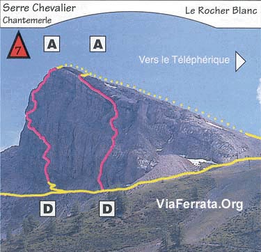
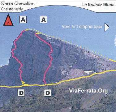
Tu as deux via ferrata à choix. Celle de gauche est plus raide avec plus de gaz, mais très bien équipée.
Celle de droite est un peu plus facile et moins raide.Tu arrives à faire les deux via dans la même journée si tu pars assez tôt.
Les montées se font dans des murs raides mais courts avant d'arriver sur une arrête rocheuse. Du sommet, tu as une magnifique vue. Tu remarqueras le calcaire et grés rose!
Retour
En 30 minutes jusqu'aux remontées mécaniques.
Ou dormir
Voir avec l'Office du Tourisme
Photos
par Chaîne de zebrprod, Youtube
-
29e Via Ferrata Le Rocher Blanc, Serre Chevalier, Saint Chaffrey, Hautes-Alpes, France
Via Ferrata Le Rocher Blanc, Serre Chevalier, Saint Chaffrey, Hautes-Alpes
Footbridge Monkey Bridge Ladder Zipline 0 0 0 0 Features
2 easy via ferratas side by side. They are accessible via the lifts! You can go up on foot, but it will take you 4 hours to get to the via ferrata.
ViaFerrata Tips and Tricks
Be careful of falling rocks and contact the station to see if the lifts are open.
You are in a mountain environment: make sure you bring proper hiking shoes, good sunglasses, sunscreen, a waterproof jacket that will keep you warm if it rains, and something to munch on if you get hungry. Just let Kilian Jorent go in his running shoes and shorts!
If you are a fan of MTB, you can take your bike and come back down on two wheels. It's really nice.
Grade
Strength Via left: 2
Via right: 1Dizziness Via left: 2
Via right: 1Type High-Mountain: 1 Technics Via left: 1
Via right: 1Evaluation Via left: Difficult
Via right: mid-DifficultInformation
Via Ferrata Le Rocher Blanc, Serre Chevalier, Saint Chaffrey, Hautes-Alpes
Length & Altitudes
Start : 2,370 m
Elevation gain: 105 m
Summit: 2,475 mTime of Year
End of June/beginning of July to end of August with the possibility of taking the lifts.
Timing
Approach, without taking the lifts: 4h
Approach, with lifts: 20 min
Via ferrata : 1h30 - 2h00
Way Back : 30 minBy Car
Towards Serre-Chavalier. La via ferrata is found in the communce of ST-Chaffrey, near the base of the lifts.
You can also leave from Briançon but you will have to walk 1h30 to get to the via from the top of the Prorel lifts.
By Train
Check with the S.N.C.F .
Access
The lifts leave about every 15 minutes and go up to 2,480m.
At the top of the lifts you go down the ridge on the left until you reach the pass. Then you scramble towards the Rocher Blanc. Once you see the sign for the via ferrata you are there. If you have the coice start with the harder of the two (if you came to do both).
You can also take the Prorel lifts in Briançon, but it will be1h30 of approach.
Via Ferrata
You have the choice between two via ferratas. The one on the left is steeper and more vertiginous, but very well equipped.
The one on the right is a bit easier and not as steep.If you leave early enough you can do both via ferratas in the same day.
The climbs are on steep walls, but they are short and then you get to a rocky arrête. From the summit you have a magnificent view. You will certainly notice the pink limestone and sandstone!
Way Back
30 minutes to the lifts.
Where to Spend the Night
Check with the Tourism Office
Media
par Chaîne de zebrprod, Youtube
-
30 Via Ferrata Rocher du Bez, Serre Chevalier, Hautes Alpes, France
Via Ferrata Rocher du Bez, Serre Chevalier
Passerelle Pont Népalais Echelle Tyrolienne 0 0 0 0 Caractéristiques
Pour les débutants et les enfants. Une partie de la via ferrata a des barreaux rapprochés pour les enfants.
Tu trouves deux via ferrate. L'Ancienne" est facile et en deux parties avec au milieu un passage "crevasse" dans la falaise.
Conseils ViaFerrata
Durant le début de saison, regarde si le chemin d'accès pour la voiture est jouable. Il est parfois gorgé d'eau
Cotation
Physique 1 Gaz 1 Type Haute-Montagne: 2 Technique 1 Evaluation Facile Information
Office du tourisme de Serre Chevalier
Longueur et Altitude
Départ : 1'620 m
Arrivée : 1’720
Dénivelé : 100m
Longueur : 350 mPériode
Avril - Octobre
Horaire
Approche : 20 min
Via ferrata : 1h00
Retour : 20 minPar la route
Passe Serre-Chavalier. La via ferrata se trouve sur la commune de Villeneuve la Salle
Par le Train ou le Bus
Voir avec la SNCF. horaires et tarifs.
Accès
Dans la commune de Villeneuve la Salle, tu vas suivre la rivière jusqu'au parking du Parc Aventure. Tu continues pour te parquer 200m plus haut.
Le panneau de la via ferrata est sur ta droite.Via Ferrata
Cette via ferrata se compose en 2 parties ou 2 via si tu préfères.
La première partie est très facile pour les enfants et les débutants où tu passeras dans les entrailles de la falaise.
La deuxième débute sur la gauche du rocher d’escalade. Elle offre un peu plus de vertige, mais c’est abordable pour tous.Retour
Les marches d'approche et de retour peuvent paraître assez longues.
Où dormir
Voir avec l'Office du Tourisme
Média
vidéo par David Cracou, Youtube
-
30e Via Ferrata Rocher du Bez, Serre Chevalier, Hautes Alpes, France
Via Ferrata Rocher du Bez, Serre Chevalier, Hautes Alpes
Footbridge Monkey Bridge Ladder Zipline 0 0 0 0 Features
For first-timers and children. In one part of the via ferrata the rungs are purposefully closer together for children.
You will find two via ferratas. "L'Ancienne" ("The Ancient") is easy and in two parts with a "crevasse" section in the middle of the cliff.
ViaFerrata Tips and Tricks
At the beginning of the season, check to see if the road is accessible for cars. Sometimes it is flooded with water.
Grade
Strength 1 Dizziness 1 Type High Mountain: 2 Technics 1 Evaluation Easy Information
Serre Chevalier Tourism Office
Length and Altitude
Start : 1,620 m
End : 1,720
Elevation gain : 100m
Length : 350 mTime of Year
Check with the tourism office.
Timing
Approach : 20 min
Via ferrata : 1h00
Way back : 20 minBy Car
Go past Serre-Chavalier. La via ferrata is found in the commune of Villeneuve la Salle
By Train or Bus
Check with the SNCF. schedules and fares.
Access
Dans la commune de Villeneuve la Salle, tu vas suivre la rivière jusqu'au parking du Parc Aventure. Tu continues pour te parquer 200m plus haut.
Le panneau de la via ferrata est sur ta droite.Via Ferrata
This via ferrata is made up of 2 parts or 2 via ferratas, whichever you prefer.
The first one is very easy for children or beginners and you will pass through the guts of the cliff.
The second one starts to the left of the climbing rock. It is a bit more vertiginous, but it is accessible for all.
Way Back
The approach walk and the way back can both seem long.
Where to Spend the Night
Check with the Tourism Office
Media
vidéo par David Cracou, Youtube


