")


via ferrata
-
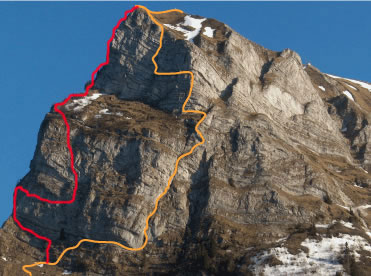
505e Via Ferrata Tour d'Ai, Leysin, Vaud, Switzerland
Via Ferrata Tour d'Aï, Leysin, Vaud
Footbridges Monkey Bridge Ladder Zipline 2 0 0 0 Features
Vertiginous with a superb panorama on Lake Geneva, the Valais Alps, and Mt-Blanc. A bit difficult for children and beginners.
Some steps are a bit high/too far for people of average height.
 ViaFerrata Tips and Tricks
Take your mountain bike (MTB) with you or rent one there, for the way down to Leysin is very nice.
A picnic is a must. At the summit of the via ferrata you can enjoy the incredible panorama while you eat.
Parking. We already received some messages from the Tourism Office and some inhabitants of Leysin lamenting our rant about the fact that there are no free parking spaces for the users of the via ferrata.
Consequently, we are making an effort to commend this great initiative to welcome tourists to the station with a fine if they do not pay for their parking and we really think its super cool and nice that they put a free parking lot 4km away from there. It would have been totally stupid for them to offer a combined lift and parking ticket for the users of the via ferrata as we suggested.Grade
Strength 2 Dizziness 2 Type High-Mountain: 1 Technics 1 Evaluation Difficule Information
Office du Tourisme de Leysin
Lifts: Télé-Leysin.
 Length and Altitude
Lenght 320 m.
Elevation Gain: 150 m.
Time of Year
End of May to mid-October. Check with the lifts for the official start of the season.
Not practicable in the winter.Timing
Approach from the top of the lift: 45 minutes
Via Ferrata 1h00 à 1h30
Way down to the mountain pasture: 45 minutes
To the parking lot: 30 minutes with an MTB, and 1h30 by foot. By Car
From Geneva, take the highway towards Lausanne and then Sion-Martigny. From Chamonix and Aosta take the highway towards Martigny-Suisse. In Martigny take the highway towards Lausanne-Geneva. Exit at Aigle (25km).
In Aigle take the N 11, towards Château d'Oex, les Diablerets, Leysin.
 By Train
Prends le train jusqu'à Aigle et ensuite jusqu'à Leysin.
Take the train to Aigle and then to Leysin.
Contact the SBB, for train and bus schedules and fares. Access
Take the Berneuse lift.
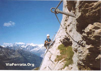
There are few indications and markings, so you must have faith. When you arrive at the summit of the lifts you will see the Kuklos rotating restaurant. Look towards the restaurant. A mountain with a cliff rises in the background to its right. This is where you will find the Tour D'Aï ferrata.
Go down the very steep trail that leads to some small houses and a charming lake. Once you are at the bottom, climb up the hill on the left following the cables and poles of the lift. You will find a little trail that will lead you to the start. (see the picture from the guide at the top of the page).
Via Ferrata
There are some difficult moves from the very beginning. If you get pass them... you should be fine for the rest. Otherwise, turn back now gringo!
A little traverse up and down... brings you to the foot of the chimney. You will have to get past it... it's a nice opportunity to play Santa Claus. We hope that after this you will realize how hard Santa really works and that this coming winter you will leave him some cookies by the chimney...
It's a bit overhanging at the end of the chimney, but only a bit, and you get to see the void all around you. You arrive tranquilly to the summit of this via. Just one more little section, great for photos. The summit of the via is almost a classic.Once you arrive on the plateau, you can make the most of an unforgettable and splendid panorama.
Way Back
The way down is a bit athletic, around 40 minutes. Be careful, there have already been deaths.
Once you arrive at the lake, you can get your bikes (if you came with your MTBs)... and off you go, down either to Leysin or Aigle.
If you came by foot, the concept is the same, but the way down to Leysin is a bit longer.
 Where to Spend the Night
Camping Semiramis: Tel: +41 24 494 11 48 .
Media
vidéo par ViaFerrata.com, Youtube
-
-
506 Via Ferrata Videmanette, Rougemont, Vaud, Suisse
Via Ferrata Videmanette, Rougemont, Vaud
Passerelle Pont de singe Echelle Tyrolienne 0 0 0 0 Caractéristiques
Il s'agit d'une initiation à la Via Ferrata pour les débutants et les enfants et un deuxième parcours un tantouné plus physique si la première partie est ok.
Astuces ViaFerrataPrends ton VTT pour la descente jusqu'à Rougemont. Un peu raide au départ, mais sympa pour la suite.
Cotation
Physique Via 1: 1Via 2: 2Gaz Via 1: 1
Via 2: 2Type Haute-Montagne
Via 1: 3
Via 2: 2Technique 1 Evaluation Via 1: Initiation
Via 2: Difficile
Information
Téléphérique Rougemont-Château d'Oex
Longueur et Altitude500 m et 200 m (2 parcours),
Départ à 2'130 m
Arrivée à 2'284 mCoordonnée GPS
N.46'27.666
E 007 12.444Période
Durant les périodes d'ouvertures des remontées mécaniques. (juin à septembre en gros).
Horaire
Marche d'approche depuis le sommet du télécabine 3 min.
ViaFerrata: 15-20 minutes
Le chemin du retour: 15 minutesPar la routeAutoroute Genève-Lausanne: sortir à Aigle -> direction Château-d'Oex.
Depuis Fribourg: sors de l'autoroute à Bulle, direction Château-dOex.
Arrivé à Château d'Oex prendre la direction Gstaad, Saanen. Arrivé à Rougemont, prends sur la droite au ronds point et descends en direction de la rivière ou des remontées mécaniques.Par le TrainLe train part de Montreux et s'arrête à Rougemont. Contacte les CFF , pour les horaires et lse tarif
AccèsMontée en téléphérique jusqu'au sommet de la Videmanette, départ de la via,
Pour les supers sportifs, il est possible de monter à pieds depuis Rougemont. Bien du courage!
Via Ferrata
Il n'y a pas de difficulté majeure à part un petit passage un tout petit peu physique et un chouilla aérien.
Excellent pour les débutants et pour ceux qui adorent marcher. La ferrata se divise en deux parties. En montant, prends la voix de gauche qui est plus en relation avec une ferrata. La voix de droite sert surtout pour la descente, sans aucune difficulté. Le sommet offre un très beau panorama
Possibilité de restauration au restaurant.
Retour
Prends le chemin qui mène au restaurant et à l'arrivée des installations.
Où dormirCamping avec piscine à Chateau d'Oex.
Photos
-
-
506e Via Ferrata Videmanette Initiation Rougemont Vaud Switzerland
Via Ferrata Videmanette, Rougemont, Vaud
Footbridge Monkey Bridge Ladder Zipline 0 0 0 0 Features
This is an introduction to Via Ferratas for beginners and children and if the first part is okay, there is a second part that is a tad more demanding.
ViaFerrata Tips and TricksTake your MTB for the way down to Rougemont. A bit steep at the beginning, but very nice in the end.
Grade
Strength Via 1: 1Via 2: 2Dizziness Via 1: 1
Via 2: 2Type High-Mountain
Via 1: 3
Via 2: 2Technics 1 Evaluation Via 1: Initiation
Via 2: Difficult
Information
Tourism Office: Rougemont-Château d'Oex
Length and Altitude500 m et 200 m (2 parts),
Start at 2'130 m
Finish at 2'284 mGPS Coordinates
N.46'27.666
E 007 12.444Time of Year
When the lifts are open. (usually June to September).
Timing
Approach from the top of the lifts 3 min.
ViaFerrata: 15-20 minutes
Way back: 15 minutesBy CarHighway Geneva-Lausanne: exit at Aigle-> towards Château-d'Oex.
From Fribourg: exit the highway at Bulle, towards Château-d'Oex.Once you are in Château-d'Oex go towards Gstaad, Saanen. Once you are in Rougemont, go right at the roundabout and go down towards the river where there are some lifts.
By TrainThe train leaves from Montreux and stops in Rougemont. Contact the SBB, for schedules and fares.
AccessTake the lifts to the top of the Videmanette, here is the start of the via,
For the super athletic, it is possible to walk up from Rougemont. Good luck!Via Ferrata
There are no major difficulties except for a small part that is a little strenuous and an ity-bity vertiginous section.
Excellent for beginners and for those who love walking. The ferrata is divided into two parts. On the way up, take the path on the left which is more like a ferrata. The path on the right is mostly used for the way down, and presents no difficulties. There is a beautiful panorama at the summit.
It is possible to dine at the restaurant.
Way Back
Take the path that leads to the restaurant and the top of the lifts.
Where to Spend the NightCamping with a pool in Chateau d'Oex.
Media
-
-
507 Via Ferra Videmanette 3, Rougemont, Vaud Suisse
Via Ferrata Videmanette 3 (Sportive), Rougemont, Vaud
Passerelle Pont de singe Echelle Tyrolienne 0 0 1 0 Caractéristiques
Hyper aérienne avec des passages techniques.
Prises directes sur le rocher, grands distances entre les attaches de la ligne de vie.
Du vertige plein les yeux!
Astuces ViaFerrataPrends ton VTT pour la descente jusqu'à Rougemont. Un peu raide au départ, mais sympa pour la suite.
Ne t'aventure pas seul, elle est très impressionnante. Ca sent le Gaz!
Cotation
Physique 4 Gaz 4 Type Haute-Montagne: 2 Technique 2 Evaluation Très Difficile Information
Office Tourisme Rougemont-Château d'Oex
Longueur et AltitudeDépart à 2'100 m
Arrivée à 2'284 m
Longueur: 400 mCoordonnée GPS
N.46'27.666
E 007 12.444Période
Durant les périodes d'ouvertures des remontées mécaniques. (juin à septembre en gros).
Attention, l'ouverture des installations est différentes suivant les jours de la semaine.Horaire
Marche d'approche depuis le sommet du télécabine 3 min.
Via Ferrata : 45 minutes
Retour: 15 minutesPar la routeAutoroute Genève-Lausanne: sortir à Aigle -> direction Château-d'Oex.
Depuis Fribourg: sors de l'autoroute à Bulle, direction Château-dOex.
Arrivé à Château d'Oex prendre la direction Gstaad, Saanen. Arrivé à Rougemont, prends sur la droite au ronds point et descends en direction de la rivière ou des remontées mécaniques.Par le TrainLe train part de Montreux et s'arrête à Rougemont. Contacte les CFF , pour les horaires et lse tarif
AccèsMontée en téléphérique jusqu'au sommet de la Videmanette, départ de la via,
Pour les supers sportifs, il est possible de monter à pieds depuis Rougemont. Bien du courage!20 mètres avant le départ des autres via ferrata, prends sur ta gauche dans le talus qui est du côté des installations. Tu dois voir l'échelle qui débute la via. La descente est un peu difficile, prudence...
Grande Impression de vide.
Via Ferrata
Ca commence très fort par une cheminée où tu installes tes pieds de chaque côtés de la parois. Au sommet, il te faudra réfléchir pour sortir. Du Gaz avec un grand G.
C'est à se demander comment fait le Père-Noël!!! Pour tenter de te décrire le truc... tu as 3 marches... et ensuite plus rien. Une grande impression de vide se fait également sentir à cet endroit.
Si tu as de la peine avec ce premier passage, rebrousse le chemin. Le reste est encore plus difficile, mais là-haut avec le gaz, c'est une toute autre histoire.
Tu continues avec une traversée sympathique... et là... là, là... comme nous tu auras de la peine à trouver tes mots. Cette dernière partie débute immédiatement par une sensation de vide énorme. Il y a plus de 200 m sous tes petits pieds! Les marches sont assez distantes l'une de l'autre, comme les attaches du câble. Dès que tu arrives à l'échelle du vide, tu auras encore droit à un surplomb qui finira d'user tes bras.
Ensuite, tu sorts de la via, par un passage assez délicat. Fais attention de ne pas balancer des cailloux sur la tête de tes potes qui se trouvent dessous.
Au sommet, tu retrouves les voies faciles des autres via ferrataRetour
Prends le chemin qui mène au restaurant et à l'arrivée des installations.
Où dormirCamping avec piscine à Chateau d'Oex.
Photos
-
-
507e Via Ferratta Videmanette 3 Rougemont Vaud Switzerland
Via Ferrata Videmanette 3: Sportive Rougemont
Footbridge Monkey Bridge Ladder Zipline 0 0 1 0 Features
Extremely vertiginous with some technical sections.
Holds directly on the rock, big distances between the fixed points of the lifeline.
Enough vertigo to last you a lifetime!
ViaFerrata Tips and TricksTake your MTB for the way down to Rougemont. It's a bit steep at the beginning, but very nice in the end.
Don't go alone, this one is quite impressive. The void is ever present!
Grade
Strength 4 Dizziness 4 Type High Mountain: 2 Technics 2 Evaluation Very Difficult Information
Office Tourisme Rougemont-Château d'Oex
Lifts: remontées mécaniques de la Videmanette
Length and AltitudeStart 2'100 m
Finish 2'284 m
Length: 400 mGPS Coordinates
N.46'27.666
E 007 12.444Time of Year
When the lifts are open. (June to September usually).
Careful, the operating times of the lifts change depending on what day of the week it is.Timing
Approach from the top of the lifts: 3 min.
Via Ferrata : 45 minutes
Way back: 15 minutesBy CarHighway Geneva-Lausanne: exit at Aigle-> towards Château-d'Oex.
From Fribourg: exit the highway at Bulle, towards Château-d'Oex.Once you are in Château-d'Oex go towards Gstaad, Saanen. Once you are in Rougemont, go right at the roundabout and go down towards the river where there are some lifts.
By TrainThe train leaves from Montreux and stops in Rougemont. Contact the SBB, for schedules and fares.
AccessTake the lifts to the top of the Videmanette, here is the start of the via,
For the super athletic, it is possible to walk up from Rougemont. Good luck!20 meters before the start of the other via ferratas, go left into the talus that is on the same side as the lifts. You should see the ladder that starts the via. The way down is a bit difficult, be careful...
The presence of the void is sensational.
Via Ferrata
It starts off really hard with a chimney where you have to place your feet on either side of the walls. At the top, you will have to think a bit to figure out how to get out. Void with a big V.
One wonders how Santa Claus can manage this!!! I'll attempt to describe the situation for you... you have three steps... and then nothing at all. The void seems to exaggerate his presence here.
If you have trouble with this first part, turn back. The rest is even more difficult, and what's more, up above with the void, it's a whole other story.
You then continue with a nice traverse...and there... there, there... like us you will have a hard time finding words. This last part starts immediately with a huge sensation of void. There are more than 200m under your little feet! The steps are quite far from each other, as are the cable's fixed points. Once you arrive to the ladder of the void, you'll be greeted by an overhang that will use up what's left of your arms.
Next, you exit the via, through a fairly tricky section. Make sure you don't kick any rocks onto the heads of your friends climbing beneath you.
At the summit, you find the easy sections of the other via ferrats.
Way Back
Take the path that leads to the restaurant and the top of the lifts.
Where to Spend the NightCamping with a pool in Chateau d'Oex.
Media
-
-
508 Via Ferrata de Tälli, Meiringen, Berne, Suisse
Via Ferrata Tälli, Meiringen, Berne
Passerelle Pont de singe Echelles Tyrolienne 0 0 5 (78 m. d'échelles) 0 Caractéristiques
Sur deux jours, la marche d'approche est un peu longue mais de difficulté moyenne. La via comporte quelques passages aériens.
Astuces ViaFerrataPrends la carte du coin et le matériel nécessaire pour passer deux bonnes journées en montagne.
A pratiquer uniquement par temps sûr, car il n'y a pas d'échappatoires. Du névé persistant au départ, sur les vires plus en altitude et sur le sentier du retour de la face nord souvent au début de l'été (se munir le cas échéant de crampons et de piolets - mais à charge de savoir s'en servir).
Réserve ton lit avant de partir.
La via ferrata s'arrête à la crête et ne touche aucun sommet.
Cotation
Physique 4 Gaz 4 Type Haute-Montagne: 2 Technique 2 Evaluation Très Difficile Information
Longueur et AltitudeApproche : 3 heures
Départ : de la via: 2'067 m
Sommet : 2'540 m. la via ferrata s'arrête à la crête du Gadmerflue et ne touche aucun sommet.
Timing: Via Ferrata 2 heures, descente 1 heure ; 7 heures en tout.
Dénivelé : 1'390 m en ascension. Via ferrata +500 m, -700 m en descenteCoordonnée GPS
Période
Juillet à début octobre
Horaire
1er jour: 550 m de dénivelé: entre 1h et 2h de marche
2ème jour: Ca devrait faire 6 h.Par la routeLyon-Genève, A 40; Genève-Lausanne N1, à Vevez prendre la direction Berne, Bâle N12;
-> A berne, prends la direction Interlaken N6,
-> à Interlaken en route pour Méringen-Furen.Par le TrainEn car postal de Meiringen à Gadmen. Contacte les CFF , pour les horaires et les tarifs
AccèsDe Furen (1149 m) sur la route de la station inférieure du téléphérique Tälli (1171 m) jusqu'au restaurant Tälli ; pas d'arrêt officiel du car postal.
Renseignements auprès de la centrale électrique KWO à Innertkirchen, tél. 033 982 20 60.
A pied, pends brièvement le chemin d'accès de l'alpage Birchlaui (1'597 m) en remontant la pente peu boisée jusqu'au restaurant Tälli (1'716 m). Entreprendre la montée oblique en suivant le marquage blanc et bleu sous les parois abruptes du Tällistock jusqu'au départ de la via à l'Alpligerstock (2'067 m).
Via Ferrata
La ferrata commence par une échelle très raide qui conduit à une vire plane aérienne. Tu la suis à droite jusqu'à ce que l'équipement de sécurité indique à nouveau l'ascension.
La viaferrata prend de plus en plus d'altitude par des marches dans la roche, des dévers herbeux et des vires étroites ; banc en bois accueillant à un tiers de la via ferrata.
Suit une traversée assez exposée avant que la voie prenne la direction d'une vire en terrasse sur la partie supérieure de la paroi. Trois échelles verticales décalées gravissent ensuite sans problème un dièdre abrupt. Reste bien concentré quand tu passes d'une échelle à l'autre… coups de cœur garantis…
Une autre échelle métallique débouche de biais sur une vire herbeuse ascendante. Pour finir, on escalade l'arête par un éboulement jusqu'à la sortie.
Signe le livre d'or qui se situe dans la grotte.
Retour
Suivre le balisage blanc et bleu jusqu'à un petit cirque rocheux (névés fréquents en début d'été). Attention quelques névés pentus peuvent être glacés.
Compte un bonne heure, puis un sentier plus où moins à plat vers le SO durant une autre bonne heure avec la remontée vers le col du Satteli (2119m). Finalement redescendre vers la Tallihutte en 45 min.
Poursuivre par la droite jusqu'au lac d'Engstlen (1850 m) et l'alpage (Engstlenalp, 1834 m).
Où dormirRefuge de Tällihutte, 20 places ouvert de la mi juin à fin octobre.
Compte env. Frs. 20.-- par personne, Tél 033 975 14 10. Hors de Suisse ++ 41 33 975 14 10
Photos & Media
par Hans Howald, Youtube -
-
508e Via Ferrata de Talli, Meiringen, Bern, Switzerland
Via Ferrata Tälli, Meiringen, Bern
Footbridge Monkey Bridge Ladders Zipline 0 0 5 0 Features
Takes two days, the approach is a bit long, but of mid-range difficulty. The via has several vertiginous sections.
ViaFerrata Tips and TricksTake the map of the area and all the gear you need to spend two long days in the mountains.
Only go if the weather is good and stable because there are no way outs. At the beginning of the summer snowfields remain at the start, on the ledges at higher altitudes and on the return path of the north face (equip yourself with crampons and an ice-axe if needed- but you must know how to use them).
Reserve a place at the hut before leaving.
Grade
Strength 4 Dizziness 4 Type High-Mountain: 2 Technics 2 Evaluation Very Difficult Information
Length and Altitude1'500 m elevation gain, 600 m of which is the ferrata
Start of the via: 2'067 m
Time of Year
July to early October
Timing
1st day: 550 m of elevation gain: 2h00 of walking
2nd day: 1'000 m of elevation gain, 600 m of which is the via. This should total to 6 h.By CarLyon-Geneva, A 40; Geneva-Lausanne N1, in Vevey go towards Bern, Basel/Bâle N12;
->In Bern, take N6 towards Interlaken,
-> in Interlaken go towards Méringen-Furen.By TrainBy bus from Meiringen to Gadmen. Contact the SBB for schedules and fares.
AccessFrom Furen (1149m) on the road from the bottom station of the Tälli lifts (1171 m) to the Tälli restaurant; there is no official bus stop.
Information from the electric power plant in Innertkirchen, tel. 033 982 20 60.
On foot, briefly follow the trail to access the Birchlaui pasture (1,597m) by going up the sparsly forested slope to the Tälli restaurant (1,716m). Take the sidelong uphill by following the white and blue markings under the steep walls of the Tällistock until you reach the start of the Alpligerstock via (2,067m).
Via Ferrata
The ferrata starts with a very steep ladder that leads to a flat vertiginous ledge. Follow it towards the right until the security equipment indicates a new ascent.
The via ferrata gains more and more altitude with some steps in the rock, grassy overhangs, and narrow ledges; there is a welcoming bench one third of the way up the via ferrata.
Follow a fairly exposed traverse before taking the path that leads to a kind of terace ledge on the upper part of the rock wall. Three staggered vertical ladders allow you to easily climb an abrupt dihedral. Stay focused when you go from one ladder to the next...your heart will skip a beat!
Another metallic ladder leads sideways to an ascending grassy ledge. To finish, we climb the ridge via a landslide to the exit.
Sign the golden book that is found in the cave.
Way Back
Follow the white and blue markings to a rocky cirque (snowfields often remain here at the beginning of summer). Be careful as some of the steeper snowfields can be icy.
It will take a good hour, then, take a more or less flat path heading SW for another good hour, which includes the way back up towards the Satteli pass (2119m).
Lastly go back down towards the Tallihutte in about 45 min.Where to SleepRefuge de Tällihutte, 20 spots available, open from mid-June to end of October.
Account for about 20.-- Frs. per person, Tel. 033 975 14 10. If calling from outside of Switzerland ++ 41 33 975 14 10
Media
by Hans Howald, Youtube -
-
509 Via Ferrata Diavolo, Andermatt, Uri, Suisse
Via Ferrata Diavolo, Andermatt, Uri
Passerelle Pont de singe Echelles Tyrolienne 0 0 2 0 Caractéristiques
Pour les débutants où les enfants, même si bien des adultes sont de grands enfants, pensa tout bas le Petit Prince...
Toute la voie domine le fameux Pont du Diable.Itinéraire vraiment spectaculaire à travers les rochers de granit du Schöllenen, ponctué de parties herbeuses.
Astuces ViaFerrataAttention: la voie est équipée de 265 pieux/pitons et non pas de marches métaliques. Peut être dangereux si c'est humide.
Prévois une 1/2 journée pour cette via ferrata, puis zoup dans ta voiture, passe le col du Susten et vas au refuge de Tälli (ce nest pas bien loin). Ainsi dès l'après midi, tu pourras te faire la ferrata deTalli et passer ainsi du granit au calcaire... et que voila une bonne idée pour un week-end... Cette option est réservée à ceux qui ont du physique et qui sont en forme.
A cause des pieux/clous qui sont utilisés à la place des marches traditionnelles, prends d'excellentes chaussures de marche.
Cotation
Physique 1 Gaz 2 ype Haute-Montagne: 3 Technique 2 Evaluation Initiation Information
Office du Tourisme d'Andermatt. Ils parlent français
Longueur et AltitudeDépart: 1'410 m
Arrivée: 1'860 mDénivelée 450 m
Période
Mi-Juin - Octobre
Horaire
Approche: 10 minutes
Ferrata: 1h30
Descente: 45 minutesPar la route1 km avant Andermatt sur le site du pont du Diable.
Tu y arrives en quittant l'autoroute Lucerne-Lugano juste avant l'entrée nord de tunnel du Gothard (sortie Göschnen) et en prenant la route du col (sortie autoroute - pont du diable = 8 km environ).
Par le TrainLe train Furka-Oberalp de Göschenen à Andermatt. 20 petites minutes à pied, et hop, tu sents déjà l'air de la via ferrata (le Pont du Diable)
Contacte les CFF, pour les horaires et tarifs.AccèsDe la gare d'Andermatt par la rue principale (panneau indicateur) par l'Urner Loch dans la gorge de Schöllenen.
Début de la via vers le bistrot du pont du diable à coté du monument à la mémoire de l'armée de Souvarov (50 mètres à pied depuis la route et le parking !)
Via Ferrata
Elle se déroule dans cet endroit magique, tout en granit, avec des passages herbeux parfois raides et patinants si c'est humide.
Le câble est sur toute la longueur. Il y a quelques barreaux et pas mal de pitons et 2 échelles. Et pour ton bonheur, il n'y a pas de passages "à bras musclé".
Au 2/3 petit banc pour une pause et surtout pour la vue... Le cadre est très chouette avec une rivière qui file dans une gorge et les sommets des alpes à l'entour.
Une longue traversée non assurée mène à la finale de l'itinéraire (livre d'or) : un couloir, un angle rocheux exposé et pour terminer une échelle verticale, et on arrive au bord du Tüfelstalboden (env. 1860 m). Juste un peu plus haut, belle aire de repos sous le drapeau de l'Uri avec vue sur les pointes de granit du Salbitschijen.
Retour
De là sortie de la via ferrata, le sentier est bien indiqué (marques blanc/bleu/blanc) pour redescendre sur Andermatt, puis le long de la route pour rejoindre la voiture le tout (descente) en 45 minutes.
Où dormirDepuis que les autorités ont laissé construire une grosse verrue en forme de Palace surdimensionné (mais vide), il est difficile de dormir pour un prix raisonnable dans le coin.
Nous avons testé l'Auberge de Jeunesse à 5 km d'Andermatt: Walchwilerhus, Gotthardstrasse, 6493 Hospental. Ca ne paie pas de mine de dehors, mais c'est génial à l'intérieur et le staff fut très sympa.
Tel. +41 (0)41 759 80 10Photos
par uster727, Youtube -
-
509e Via Ferrata Diavolo, Andermatt, Uri, Switzerland
Via Ferrata Diavolo, Andermatt, Uri
Footbridge Monkey Bridge Ladders Zipline 0 0 2 0 Features
For beginners or children, even if, as the Little Prince said in a whisper, many adults are still kids at heart...
The whole route overlooks the famous Devil's Bridge.A truly spectacular itinerary through the granite of the Schöllenen, interspersed with grassy sections.
ViaFerrata Tips and TricksWarning: the route is equipped with 265 stakes/pitons and not metal steps. This can be dangerous in wet conditions.
Account for half a day to complete this via ferrata, and then zoom in your car, past the Susten pass and to the Tälli refuge (it is not very far). That way in the afternoon you'll be able to do the Talli ferrata and so pass from granite to limestone...my what a grand idea for a week-end that is... This option is only for those who have strength and are in good physical condition.
Because of the stakes/pitons that are used instead of the traditional steps, make sure you take good hiking shoes.
Grade
Strength 1 Dizziness 2 Type High-Mountain: 3 Technics 2 Evaluation Beginner Information
Office du Tourisme d'Andermatt.
Length and AltitudeStart: 1'410 m
Finish: 1'860 mElevation Gain: 450 m
GPS Coordinates
Time of Year
Mid-June to October
Timing
Approach: 10 minutes
Ferrata: 1h30
Way back: 45 minutesBy Car1km before Andermatt at the Devil's bridge site.
You can get there by leaving the Lucerne-Lugano highway just before the north entrance of the Gothard tunnel (Göschnen exit) and by taking the pass road (highway exit- devil's bridge = about 8km).
By TrainTake the Furka-Oberalp train from Göschenen to Andermatt. 20 short minutes by foot, and there you go, you already feel the via ferrata air (Devil's Bridge)
Contact the SBB, for train schedules and fares.AccessFrom the Andermatt station via the main road (there is a sign) by l'Urner Loch to the Schöllenen gorge.
The start of the via is near the devil's bridge bistro next to the monument in the memory of Souvarov's army (50 meters on foot from the road and the parking!)
Via Ferrata
The via ferrata takes place in this magic all granite setting, with some grassy sections that are steep and slippery at times if the conditions are wet.
The cable covers the entire length of the route. There are some bars, quite a lot of pitons, and 2 ladders. And for your pleasure there are no "muscle-man" sections.
2/3 of the way is a little bench where you can take a break. The view is especially worthwhile... The setting is absolutely splendid, a river winds its way through a gorge against the backdrop of high alpine summits.
A long un-secured traverse leads to the final section of the itinerary (gold book): a couloir, a rocky exposed angle and to finish a vertical ladder, and then we arrive on the edge of the Tüfelstalboden (env. 1860m). Just a bit higher is the welcome air of a nice break under the Uri flag with a view on the granite peaks of the Salbitschijen.
Way Back
From the end of the via ferrata, the path is well marked (white/red/white markings) to go back down to Andermatt, and then go along the road to get back to the car, all of this (the way down) takes about 45 minutes.
Where to Spend the NightSince authorities have let a big eyesore in the form of the oversized (but empty) Palace be built, it is difficult to find affordable accomodations in this area.
We tried out the Youth Hostel 5km from Andermatt: Walchwilerhus, Gotthardstrasse, 6493 Hospental. It doesn't look like much from the outside, but it's really nice inside and the staff was really friendly.
Tel. +41 (0)41 759 80 10Media
par uster727, Youtube -
-
51 Via Ferrata Chaos de Coumély, Gedre, Gavarnie, Hautes-Pyrenées, France
Via Ferrata Chaos de Coumély, Gedre, Gavarnie
Passerelle Pont de singe Echelle Tyrolienne 1 0 0 0 Caractéristiques
Via ferrata située à 3 kms avant le village de Gavarnie au niveau du Chaos de Coumély. 180m de dénivelé et 400m de longueur dont une passerelle/pont de singe qui bouge, qui bouge et qui n'en finit pas.
Conseils ViaFerrataSe renseigner au préalable sur les conditions à l'office du tourisme. Accès libre ou possibilité de la faire avec un guide de haute montagne. Te renseigner au bureau des guides
Cotation
Physique 3 Gaz 3 Type Montagne: 1 Technique 2 Evaluation Difficile Information
Office du Tourisme de Gavarnie
Bon, ils ne sont pas giga au point sur leur via ferrata. Bonne chance!
Longueur & AltitudesAltitude départ: 1'200 m.
Altitude d'arrivée: 1'380 m.
Dénivelée: 180 m.
Longueur: 400 m.Période
Avril à novembre (période sans neige)
Horaire
Accès Viaferata: 15 minutes
Viaferrata: 1h30 - 2h00 (office du toursime donne 3-4h, mais c'est un peu beaucoup)
Retour: 15 minutesPar la route
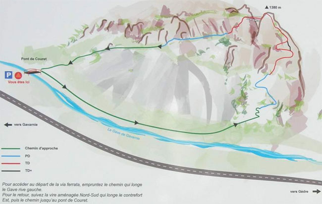
Entre Gèdre et Gavarnie, le départ se fait aprés s'être garé sur un petit parking aménagé sur la droite de la route. On longe pendant 20 bonnes minutes le gave de gavarnie sur un bon sentier qui nous amène dans le chaos de Coumély.
Par le TrainVoir avec la S.N.C.F . Via la gare de Cluse.
AccèsDepuis Gèdre, compte 3 km avant le village de Gavarnie, juste avant le camping. Parque sur la droite dans le parking, à côté d'un petit pont.
Ensuite tu traverses le pont et pars sur ta droite sur le chemin qui longe la rivière "la Grave" sur sa rive gauche.Via Ferrata
Ca commence plutôt relax et tu avances sur un chemin peu difficile avant d'atteindre le pied de la falaise. C'est l'échauffement.
Tu grimpes de manière plus grimpante sur un mur "droit en haut" très bien équipé. Plus tu montes, plus l'impression de gaz s'annonce aux abonnés présents. Si tu as le temps de prendre une photo sur le Cirque de Garvanie (attache ton appareil à une petite corde reliée à ton sac pour éviter qu'il ne s'écrase au fond du paysage, là en bas).
Après cette récréation, tu as droit à un surplomb assez court, mais ça penche dans le mauvais sens. Si tu n'as pas les bras, tu peux l'éviter.
Tu poursuis sur des vires moins pentues pour arriver à une rampe un peu spéciale où tu grimpes à califourchon. Une terrasse permet de te reposer.
Tu passes du côté Sud avec une vue sur la passerelle et plus tu avances, plus tu peux la voir bouger à la simple force du vent. Dès que tu mets les pieds sur les grilles, tu as l'impression que ça va dans tous les sens, et effectivement, ça va dans tous les sens. Par bol le gars qui l'a construit a mis un cable d'une seule longueur, donc pas de changement!
Tu redescends un petit peu pour rejoindre un mur vertical et tu passes sous les filets qui retiennent les cailloux et tu vas bientôt retrouver le chemin de retour.
Retour
Tu continues la via et le câble. Tu retrouves ta voiture en 20 minutes.
Ou dormirTu trouves un camping à 5 min de la via.
Media
par Oscar Manrique, Youtube
-
-
510 Via Ferrata de Baltschiedertal, Baltschieder, Valais, Suisse
Via Ferrata de Baltschiedertaler, Baltschieder, Valais
Passerelle Pont de singe Echelle Tyrolienne 1 0 0 0 Caractéristiques
Située dans un lieu magnifique. La vue et le cadre sont très beaux. Mais il te faudra une bonne journée pour la parcourir.
C'est long, style via ferrata dans les Dolomites.Astuces ViaFerrataTu es en haute montagne, attention aux changements de temps.
Prends des habits chauds et assez de chocolat pour les forces. Evite d’y aller s’il a plu ou si c’est humide. Il y a beaucoup de passages glissants et pas toujours sécurisés.
Cotation
Physique 4 Gaz 3 Type Haute montagne: 3 Technique 3 Evaluation Très Difficile Information
Wiwannihütte qui est la cabane qui s'occupe de la ferrata.
Longueur et AltitudeAltitude départ : 2'027 m
Altitude d’arrivée : 2'444 m
Denivellé: 910 m
Longueur Via Ferrata: 2'100 mCoordonnée GPS
Période
Juin - Octobre
Horaire
Approche Via Ferrata: 2h30 – 3h
Via Ferrata: 3-4 heures
Descente: 2h30Par la routeTraverse tout le Valais en direction de Brigue.
Après la ville de Rarogne (Raron en allemand) et à proximité de Viège ou Visp, prends la direction de Baltschieder (Baltschiedertal).
Par le TrainAccès possible depuis Sion ou depuis le canton de Berne par le Lotschberg. Contacte les CFF, pour les horaires et le tarif.
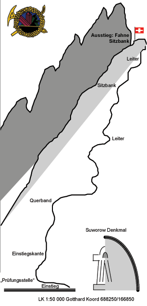
Le point sur la carte indique la cabane Wiwanni.
AccèsBon, je débute par un coup de gueule : le parking est payant !!! et c’est très cher. Compte un minimum de Frs 6 à 7.— pour ton arrêt dans la via. Bien plus, si tu dors à la cabane !
Revenons à nos moutons. Le dit parking se trouve en face du Restaurant le Sonnehalde.
Mais si tu n’aimes pas marcher, continue par la route payante en direction de Nirwarch (compte Frs. 10.--) et roule jusqu’à la première épingle à cheveux. Il y a un parking à proximité.
Sinon, tu peux laisser ta voiture en bas et faire ce bout à pied. Compte 30 minutes.
De là, suis le sentier de la Cabane Baltschieder (suivre les marques rouge et blanche). Il y a un bisse sympa qui va t'accompagner jusqu’à ce que le chemin monte de manière plus pentue. Attention, ce chemin est vertigineux par endroit étroit.
Après une bonne grimpée, tu trouves sur ta gauche un chemin Blanc/Bleu. C’est le chemin de la via ferrata.
Via Ferrata
La Via Ferrata débute par un passage escarpé et ensuite dans une faille. La pente n’est pas très raide et tu es en contact avec le rocher. C’est sympa.
Ensuite tu arrives à un petit calvaire. Un chemin interminable dans l’herbe, la boue et les rochers. Un homme averti en vaut deux, donc pas de crise de nerfs !
Le câble s’interrompt pour un passage un peu scabreux et tu rejoins la deuxième partie de la via ferrata. Là, tu passes le long d’un grand rocher qui domine les gorges. Le paysage est splendide!
La fin de la via ferrata se termine le long d’une arrête rocheuse.
Retour
Compte 30 minutes pour arriver à la cabane en suivant le sentier Bleu/Blanc.
Où dormirLa cabane de Wiwannihütte 027 923 09 03 à côté du Wiwannihorn 3001 m.
Deux hôtels dans la région:
Hotel Bahnhof 027 946 22 59
Hotel Sonnenhalde 027 946 25 83.
Photos
-
-
510e Via Ferrata Baltschiedertal, Baltschieder, Valais, Switzerland
Via Ferrata de Baltschiedertaler, Baltschieder, Valais
Passerelle Pont de singe Echelle Tyrolienne 1 0 0 0 Features
Located in a magnificent area. The view and the setting are very beautiful. But you will need the better part of a day to complete it.
It's long, in the style of Dolomite via ferratas.ViaFerrata Tips and TricksYou are in a high mountain setting, be wary of changes in the weather.
Take warm clothes and enough chocolate to keep you going. Avoid going if it just rained or if the conditions are wet. There are a lot of slippery parts and they are not always secured.
Grade
Physique 4 Gaz 3 Type Haute montagne: 3 Technique 3 Evaluation Très Difficile Information
Wiwannihütte, the hut that maintains the via ferrata.
Length and AltitudeStart: 2'027 m
Finish: 2'444 m
Elevation Gain: 910 m
Via Ferrata Length: 2'100 mGPS Coordinates
Time of Year
June-October
Timing
Via Ferrata approach: 2h30 – 3h
Via Ferrata: 3-4 heures
Way back: 2h30By CarCross the entire Valais towards Brig.
After the town of Rarogne (Raron in German) and near Viège/Visp, follow directions for Baltschieder (Baltschiedertal).
By TrainYou can get there from Sion or from the canton of Bern via the Lotschberg. Contact the SBB, for schedules and fares. The cursor indicates the Wiwanni Hut.
AccessWell, I'm going to start with a rant: you have to pay for parking!!! and it's really expensive. Have a minimum of 6 to 7.— Frs. for your place at the via. And a lot more if you're planning on sleeping at the hut!
Back to the subject. The said parking is found across from to the Sonnehalde Restaurant.
But if you don't like to walk, continue on the toll road towards Nirwarch (account for 10.-- Frs.) and drive until you get to the first hairpin. There is a parking nearby.
Otherwise you can leave your car at the bottom and walk this section. This takes about 30 minutes.
From there, follow the path towards the Baltschieder Hut (follow the red and white markings). A nice stream accompanies you until the path gets steeper. Be careful this trail is vertiginous when it is narrow.
After a good climb, you will find a white/blue marked trail on the left. This is the trail for the via ferrata.
Via Ferrata
The Via Ferrata starts with a steep section and then goes into a crack. The slope is not very steep and you are in contact with the rock. It's nice.
Next comes a little ordeal. An interminable path in the grass, mud, and rocks. He who is forewarned is forearmed, so don't have a panic attack!
The cable is interrupted by a section that is a bit risky and then you get to the second part of the via ferrata. There, you will go along a big boulder that overlooks the gorges. The landscape is incredible!
The via ferrata ends along a rocky ridge.
Way Back
It takes about 30 minutes to get to the hut when following the blue/white trail.
Where to Spend the NightWiwannihütte 027 923 09 03 next to the 3001m Wiwannihorn.
Two hotels in the area:
Hotel Bahnhof 027 946 22 59
Hotel Sonnenhalde 027 946 25 83.
Media
-
-
511 Via Ferrata Jägihorn, Saas Fee, Valais, Suisse
Via Ferrata de Jägihorn, Saas Fee en Valais
Passerelle Pont de singe Echelles Tyrolienne 0 0 5 0 Caractéristiques
Départ d'une cabane à 2'726 m... 5 échelles avec 400 échelons...
Astuces ViaFerrataIl s'agit d'un véritable parcours haute-montagne où tu vas grimper jusqu'à 3'206 m. Prends des habits et un équipement en conséquence.
Cette ferrata est très longue. Tu as intérêt à avoir la pêche et une excellente condition physique pour la parcourir.Cotation
Physique 4 Gaz 3 Type Haute Montagne: 2 Technique 2 Général Très Difficile Information
Office du Tourisme de Saas Fee
Longueur et AltitudePlus de 1'000 m. de câble.
Départ de la Via Ferrata: 2'820 m.
Sommet de la ViaFerrata: 3'206 m.Coordonnée GPS
Période
De fin juin à septembre.
Horaire
Approche: 1h15
ViaFerrata: 3h00
Retour: 1h30
Compte entre 5-7 heures pour la parcourir!!!Par la routeAutoroute du Valais direction Brigue. De Brigue prends la direction de Saas Fee - Zermatt. Compte une bonne heure de route depuis Sion.
Par le TrainIl y a un train jusqu'à destination. Contacte les CFF , pour les horaires et le tarif.
AccèsPrends le téléphérique Saas-Grund - Kreuzboden 2400. Ensuite une bonne heure et 15 minutes pour l'approche.
De la station de Kreuzboden (2'397 m) vers les cabanes de Weissmies. Un panneau indique la via ferrata. Prends le sentier balisé en passant sur le Triftbach, puis grimpe la crête escarpée de la moraine jusqu'à la longue traversée en plan pour le départ de la via ferrata (env. 2820 m).
Via Ferrata
Tu contournes une saillie rocheuse par la gauche grâce au câble de vie, puis tu grimpes avec des marches sur un couloir caractéristique.
De là, ça devient de plus en plus pentu. Il y a des crochets là où les prises manquent. Fais attention à ne pas provoquer de chutes de pierres !
L'escalade du rocher rude et abrupt est stimulante, en partie aérienne jusqu'à la première échelle.
Succession d'échelles plus haut sur la paroi. C'est assez physique. Tu accèdes aux derniers échelons par un versant escarpé, juste sous l'antécime (3150 m).
À gauche après une vire vient une descente sécurisée presque en continu (une échelle) et partiellement aérienne le long de l'arête ouest jusqu'à la brèche (3096 m) devant le Jägihorn.
Passe à gauche de l'arête acérée (très originale) jusqu'au point de départ de l'ascension du sommet proprement dit. Au bloc rocheux, ascension d'abord légère puis de plus en plus escarpée et aérienne. Vient un passage abrupt particulièrement original où les crampons sont montés directement par-dessus l'arête.
Pour finir, replat menant au vaste sommet.
Retour
Compte 30 minutes pour arriver à au Refuge de Weissmies en suivant le sentier Bleu/Blanc dans la face ouest pour descendre jusqu'à un couloir rocheux escarpé.
Fais gaffe, c'est gazeux. La descente en zigzag mène au vallon par éboulis abrupt. Au choix, tu poursuis vers les cabanes de Weissmies ou directement vers la vallée jusqu'à la station Kreuzboden.
Où dormirRefuge de Weissmies : +41 (0)27 957 25 54
Vidéo par OutdoorRolf
Photos
-
-
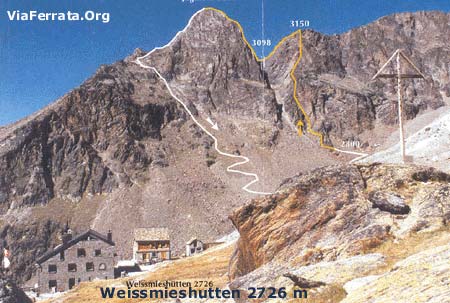
511e Via Ferrata Jägihorn, Saas Fee, Valais, Switzerland
Via Ferrata de Jägihorn, Saas Fee in Valais
Footbridges Monkey Bridge Ladders Zipline 0 0 5 0 Features
Starts from a hut at 2,726m... 5 ladders with 400 rungs...
ViaFerrata Tips and TricksThis is a veritable alpine route where you will climb all the way to 3,206m. Take the necessary clothes and equipment.
This ferrata is very long. You had better be feeling your best and in excellent shape to complete it.Grade
Strength 4 Dizziness 3 Type High Mountain: 2 Technics 2 Evaluation Very Difficult Information
Saas Fee Tourism Office
Length and AltitudeMore than 1'000 m. of cable.
Start of the Via Ferrata: 2'820 m.
End of the ViaFerrata: 3'206 m.GPS Coordinates
Time of Year
End of June to September.
Timing
Approach: 1h15
ViaFerrata: 3h00
Way back: 1h30
It takes 5-7 hours to complete the whole thing!!!By CarValais highway towards Brig. From Brig go towards Saas Fee- Zermatt. It takes about an hour from Sion.
By TrainThere is a train to this destination. Contact the SBB, for train schedules and fares.
AccessTake the Saas-Grund-Kreuzboden 2400 lift. Then for the approach you'll walk a good hour and 15 minutes.
From the Kreuzboden station (2,397m) towards the Weissmies huts. A sign points to the via ferrata. Take the marked trail passing on the Triftbach, then climb the steep crest of the moraine until you get to the long flat traverse to the start of the via ferrata (about 2820m).
Via Ferrata
You go around a rocky projection on the left thanks to a life-line, then you climb on some steps in a characteristic couloir.
From there, it gets steeper and steeper. There are some hooks where holds are lacking. Be careful not to provoke any rock falls!
The rough and abrupt climb of the rock is stimulating, it is a bit vertiginous to the first ladder.
A series of ladders higher up the wall. It's fairly strenuous. You get to the final rungs via a steep slope, juste below the secondary summit (3150m).
To the left after a ledge is a secured almost continuous downclimb (a ladder) and it is partially vertiginous along the west ridge until the gap (3096 m) in front of the Jägihorn.
Go to the left of the sharp ridge (very original) to the starting point of the ascent towards the proper summit. At the rocky block, the climb is at first easy and then gets more and more steep and vertiginous. Now comes a particularly original abrupt section where the crampons are placed directly over the ridge.
To finish a flatter part leads to the wide summit.
Way Back
It takes about 30 minutes to get to the Weissmies Refuge by following the blue/white trail in the west face of the mountain that descends to a steep rocky couloir.
Be careful, it's vertiginous. The way down zig-zags and leads to the small valley via an abrupt pile of fallen rocks. Here you can choose to go towards the Weissmies hut or go directly towards the valley to the Kreuzboden station.
Where to SleepWeissmies Refuge: +41 (0)27 957 25 54
Vidéo par OutdoorRolf
Photos
-
-
512 Via Ferrata Tichodrome Noiraigue Val de Travers Neuchatel Suisse
Via Ferrata Tichodrome Noiraigue, Val de Travers, Neuchâtel
Passerelle Pont de singe Echelles Tyrolienne 0 0 0 0 Caractéristiques
Découvre le Val-de-Travers sous un angle différent. Belles sensations de vide.
Elle est fermée annuellement du 1er janvier au 1 juillet, ceci afin de permettre au Faucon pèlerin, au Faucon crécerelle et au Tichodrome échelette de nidifier dans la tranquillité.Les câbles d'entrée et de sortie sont retirés chaque saison, empêchant ainsi l'accès à la falaise.
Astuces ViaFerrataCette via convient bien aux initiations et aux enfants dès 10 ans, elle n'est pas équipée de tire-bouchons donc prends tes dégaines pour encorder les enfants.
Le coin est plutôt humide. De bonnes semelles en Vibram et des chaussures de marche sont nécessaires. Il y a une antenne, passe y faire un tour pour voir le lac de Neuchâtel.
Question pour un champion: Pourquoi le nom Tichodrome ?
Il s’agit du nom des oiseaux qui nichent dans les falaisesCotation
Physique 1 Gaz 2 Type Plaine: 2 Technique 1 Evaluation Initiation, débutant Information
Tourisme Neuchâtelois Val-de-Travers.
Association « Via ferrata et escalade sportive »
Centre sportif du Val-de-Travers: www.centresportif-vdt.chLongueur et AltitudeLongueur du câble : 550 mètres, pas d'échappatoire possible
Dénivellation : 150 mètres
Altitude du Départ: 950m
Altitude Arrivée: 1150mPériode
Ouverte du 1er juillet au 31 décembre (par réglementation pour la nidification des oiseaux, les câbles d'entrée à la voie sont enlevés hors de ces dates.
Horaire
Approche: 5 min
ViaFerrata: 1h00
Retour: 5 minPar la routeDe Neuchâtel suivre la direction du Val-de-Travers, Peseux, Rochefort, Noiraigue, à la sortie du tunnel de la Clusette, monte en direction des Ponts-de-Martel et tu y es. Parking du Haut de la Côte.
De la Chaux-de-Fonds, suis la direction Val-de-Travers, la Sagne, Brot-Dessus. Parking du Haut de la Côte.Par le TrainNeuchâtel- Noiraigue (puis à pied jusqu'à la via env. 1h00)
Chaux-de-Fonds – Les Ponts-de-Martel (puis à pied jusqu'à la via 45 min. – 1h00). Contacte les CFF , pour les horaires et le tarif.AccèsA pied, on accède au départ de la Via Ferrata de la gare des Ponts-de-Martel (45 minutes), de la gare de Noiraigue (1 heure) ou du restaurant du Haut de la Côte (10 minutes).
À partir du parking, longer brièvement la crête sur un sentier balisé puis se tenir à droite vers la route asphaltée plus bas. Croiser cette route et parcourir la forêt jusqu'au départ.
Via Ferrata
Une belle vire sur les hauteurs de Noiraigue.
Creusé au fil du temps dans la roche, Michel Gentil, guide et son association "Via Ferrata et escalade sportive" ont fait de cette vire une agréable via ferrata. Son équipement et ses informations sont particulièrement soignés. Un seul passage qui pourrait faire frémir les moins audacieux, passage sur un surplomb.
Magnifique point du vue sur le lac de Neuchâtel au sommet de la via.Tu débute en traversant un ressaut rocheux de la montée en passant par des vires naturelles. Des passages faciles alternent avec des passages aériens où le câble n'est pas complètement tendu et tu surplombes le vide. Le Surplomb du Nid offre beaucoup de gaz sous tes pieds. L'itinéraire bifurque avant le point de vue (1'119 m), mais celui-ci vaut absolument un petit détour.
Retour
Au choix à gauche le long de l'arête sur le sentier d'altitude du Jura vers le départ (et retour à la gare) ou par la crête boisée qui domine le parking du restaurant. C'est bien indiqué.
Où dormirToutes les infos pour dormir, manger, faire de belles randonnées ou découvrir la région du Val-de-Travers, ses musées, ses particularités auprès de Tourisme neuchâtelois Val-de-Travers.
Vidéo par AandG2009, YoutubePhotos
-
-
512e Via Ferrata Tichodrome Noiraigue, Val de Travers, Neuchatel, Switzerland
Via Ferrata Tichodrome Noiraigue, Val de Travers, Neuchâtel
Footbridge Monkey Bridge Ladder Zipline 0 0 0 0 Features
Discover the Val-de-Travers from another perspective. Excellent vertiginous sensations.
It is closed annually from the 1st of January to the 1st of July so as to allow Peregrin Falcons, Kestrels, and Wallcreepers to nest in peace.The entry and exit cables are removed each season, thus blocking access to the cliff.
ViaFerrata Tips and TricksThis via is great for first timers and kids 10 or older, take your quickdraws as it is not equipped properly for you to secure your kids with a rope.
This area is rather humid. Good Vibram soles and hiking shoes are necessary. There is an antenna, go have a look at it to see the Neuchâtel lake.
A question for the champs: Why is it called Tichodrome?
This is the French name for the bird that nests in these cliffs (Wallcreeper in English).Grade
Strength 1 Dizziness 2 Type Plain: 2 Technics 1 Evaluation Beginner. Easy Information
Tourisme Neuchâtelois Val-de-Travers.
Association: « Via ferrata et escalade sportive »
Centre sportif du Val-de-Travers: www.centresportif-vdt.chLength and AltitudeCable length : 550 meters, no exit possible
Elevation gain : 150 meters
Start elevation: 950m
End elevation: 1150mTime of Year
Open from the 1st of July to the 31st of December (due to the bird nesting regulations, the entry cables to the route are removed outside of these dates).
Timing
Approach: 5 min
ViaFerrata: 1h00
Way Back: 5 minBy CarFrom Neuchâtel go towards Val-de-Travers, Peseux, Rochefort, Noiraigue, at the exit of the Clusette tunnel, go towards Ponts-de-Martel and you are there. Haut de la Côte parking.
From Chaux-de-Fonds, go towards Val-de-Travers, la Sagne, Brot-Dessus. Haut de la Côte parking.By TrainNeuchâtel-Noiraigue (then on foot to the via, about 1h00)
Chaux-de-Fonds-Les Ponts-de-Martel (then on foot to the via 45 min.-1h00). Contact the SBB, for schedules and fares.AccessOn foot, you can get to the beginning of the Via Ferrata from the Ponts-de-Martel station (45 minutes), from the Noiraigue station (1 hour), or from the Haut de la Côte restaurant (10 minutes).
From the parking, go briefly along the ridge on a marked trail and then head right towards the asphalt road lower down. Cross this road and go through the forest until you get to the start.
Via Ferrata
A nice ledge above Noiraigue.
Michel Gentil and his association, "Via Ferrata et escalade sportive" dug into this rock over time to make a very enjoyable via ferrata out of this ledge. The equipment and information he used were very carefully chosen. There is only one section that could make those who are less brave shudder, an overhanging section.
Magnificent view on the Neuchâtel lake at the top of the via.
You start by crossing a rocky projection on the way up by passing on natural ledges. Easy sections alternate with vertiginous sections where the cable is not completely taught and you hang out over the void. A good dose of void stretches out below your feet at the Nest Overhang. The itinerary splits before the view point (1,119 m), but this view is absolutely worth the detour.
Way Back
You can either go left along the ridge on the higher altitude Jura trail towards the start (and return to the train station) or you can go on the forested ridge that overlooks the restaurant parking. It is well indicated.
Where to Spend the NightAll the information for where to spend the night, to eat, to go on beautiful hikes, or to discover the Val-de-Travers region, its museums and its particularities, is available from the Neuchâtel Val-De-Travers Tourism.
Vidéo par AandG2009, YoutubeMedia
-
-
513e Via Ferrata d'Evolène, Evolène, Valais, Switzerland
Via Ferrata d'Evolene, Evolène in Valais
Footbridge Monkey Bridge Ladder Zipline 0 0 1 0 Features
In 3 parts...and none are insignificant...
1 ladder, 3 overhanging sections that work the arms, beautiful view on Evolène. And vertiginous!
Not for everyone. Only for those who have already done via ferratas before.ViaFerrata Tips and TricksIf you do this one at sunset... you will enjoy a view that is absolutely magnificent. There are three parts and an escape route exists between the three parts.
Bring your camera, the view of the village is very beautiful
Grade
Strength Partie 1: 3
Partie 2: 1
Partie 3: 4Dizziness Partie 1: 3
Partie 2: 2
Partie 3: 4Type Mountain: 1 Technics 2 Evaluation Extreme Information
Office du Tourisme d'Evolène.
Length and AltitudeLength: 700 m
Elevation gain: 400 m
Altitude: 1'497 mGPS Coordinates
N 46’06.460
E 007’30.242Time of Year
From spring to autumn.
Timing
Approach: 5 minutes
Via Ferrata
Part 1: 15-20 minutes
Part 2: 5-10 minutes
Part 3: 25 minutesWay back: 15 minutes
By CarRendez-vous in Valais. From Geneva take the highway towards Lausanne-Sion. From Chamonix and Aoste go towards Martigny and then take the highway towards Sion.
In Sion, take the second exit (hospital). Go off to your left and at the last roundabout where the Tamoil Gas Station is, go towards Vex, Val d'Hérens. Evolène is found up there. On the road you'll see the Euseigne pyramids. It's beautiful!
By TrainGo to Sion and then take the bus from the Sion train station.
Contact the SBB for train fares and schedules.
AccessDon't go into the village of Evolène, stay on the road that goes to Arolla.
200m after the Coop store, you'll find a little parking lot on your left. That's when you'll give your wheels a break and put your muscles to work.
Go up towards the forest (mountainside) to find your way to the base of the cliff. Everything is marked.To get to the beginning of the "easy" part of the "Chamois Ledge", take the path that goes up on the right.
Via Ferrata
Your journey starts with an overhang that, on top of taking your breath away, drains your arms of strength! The first overhang is followed by a second that is no less tricky. For your humble servant, who is taller than most, it was all rock & roll.
If you get past this first obstacle, you should be fine for the rest. Otherwise, the goose is cooked at this point, it's all over. Give up and go to the Via Nax...
Next comes a more tranquil section: a traverse where you are in contact with the rock, where you will be able to enjoy the view. After going up a nice ladder, you find yourself at the escape route: The Mélèze.
Chamois LedgeThe second part, the "Chamois Ledge," is a simple transition to the last part. If you want to leave before the last part, you can exit at the Mélèze.
The Big Wall
A splendid vertical wall of 130m. It's overhanging, strenuous, nerve-wracking, and vertiginous. Simply put, if you are not a via ferrata beast, don't go! Or if you do, hire a guide. The local guides are very competent and if you ask them, they'll speak to you in the local dialect! (Evolène has been able to keep its traditions and its language)The way back from the Big Wall is splendid (see the picture) as you have the Dent Blanche peak in front of you! The trail to go back is very well maintained. It's a real delight!
Way Back
You can either go to the left along the ridge on the Jura altitude trail towards the start (and back to the train s tation) or by the forested crest that dominates the restaurant parking lot. It's well signed.
Where to SleepEvolène Campground
ViaFerrata.com Youtube
Media
-
-
514 Via Ferrata Voie Hohl, La Face, Moleson, Fribourg, Suisse
Via Ferrata Voie Hohl, La Face, Moléson, Fribourg
Passerelle
Pont de singe Echelle Tyrolienne 0 0 0 0 Caractéristiques
Splendide panorama, longue, variée. Pas pour les débutants bien que la sortie finale a été facilitée. En effet, le dernier surplomb, qui surplombait la via, a été ratiboisé car il avait tendance à créer un bouchon à cause de ceux qui surestimaient leurs muscles.
Payante: Frs. 4.-- pour les adultes, Frs. 2.-- enfants.
Astuces ViaFerrataPrends le pic-nic avec toi. Le panorama du sommet de la via ferreta se déguste à pleines dents et le restaurant accepte les pique-niqueurs! (prends une boisson... ils sont sympas...).
La via est entièrement à l'ombre. Une petite laine si le temps n'est pas très chaud...
Le Moléson est une super station!!! Après la via profite pour faire de la luge d'été, du dévale kart ou de la Trotine Herbe...
Les remontées mécaniques sont ouvertes dès 09h00. Vérifie qu'elles sont ouvertes si tu veux prendre le funi pour rejoindre la via ferrata.A manger dans la région: la crème double de la Gruyère avec ses meringues.
Cotation
Physique 3 Gaz 2 Type Haute Montagne: 2 Technique 1 Evaluation Difficile Information
Office du Tourisme de Moléson Gruyère.
Longueur et AltitudeLongueur: 1'310 m
Dénivellation: 372 mètres
Départ: 1'630mCoordonnée GPS
N 46'33'363
E 007'33'363
Alt. 1'522 m.Période
Avril à Novembre (sans neige).
Horaire
Marche d’approche depuis l'arrivée du funiculaire: 20 minutes
Via Ferrata: 2h30 heures
Marche de retour: retour en télécabine depuis le sommet du Moléson. A pieds, 1h30Par la routeA 12 Vevey - Fribourg-Berne, Sortie Autoroute: Bulle
A la sortie de l'autoroute, prends la première sortie du rondpoint (à côté de la station d'essence) en direction du Moléson - Gstaad
Puis "Le Moléson"Par le TrainJusqu'à Bulle et ensuite en Bus ou en train jusqu'à Gruyère. Contacte les CFF, pour les horaires et le tarif.
Par Montreux: Montbovon jusqu'à Gruyères Gare, puis en Bus jusqu'à Moléson-sur-Gruyères.Contacte les CFF , pour les horaires et le tarif.
AccèsC'est du tout simple. A Moléson, parque vers le départ du Funiculaire.
Depuis le parking de Moléson-sur-Gruyères, pars sur Plan-Francey à pied (1h15) ou en funiculaire (7 min, départ toutes les 20 min, à...h00,...h20,...h40). (Frs 14.-- aller/retour)
A Plan Francey, tu peux louer du matériel via ferrata
De Plan-Francey suis les panneaux Via Ferrata pendant env 20 min et tu atteins le pied de la face. Il s'agit de la voie qui se trouve dans la face à droite, et non pas la via ferrata qui se trouve sur l'arrête à gauche.Via Ferrata
La Via Ferrata traverse la face nord du Moléson, passe par La Croix du Petit Moléson et arrive sur le sommet du... je vous le donne en mille: Moléson.
Ce n'est pas une via pour les débutants et on voit toujours des abrutis qui sont coincés en chemin. La montagne, ça se respecte!
Le départ est assez simple, sous forme de très bon échauffement. tu montes dans de belles cheminées parfois athlétiques. Le parcours a été magnifiquement dessiné.
Tu as droits à quelques passages en léger dévers... et un tantinet physique. Ces passages ne sont pas très longs... et il y a toujours un replat à proximité pour se reposer. Plus tu arrives vers le sommet, plus c'est physique. Une très belle montée dans une cheminée avec un passage à bras un peu plus physique.
La dernière partie est absolument superbe. Comme il y avait trop de débutants qui faisaient de l'initiation et se trouvaient bloqué, le dernier dévers a été supprimé. Dommage!La via est très bien équipée. Il y a parfois un peu trop de matos mais tu as souvent l'occasion d'avoir le contact avec le rocher. C'est très agréable.
Pour les personnes de grandes tailles (comme ma pomme) c'est un peu compliqué car tu seras souvent en dévers...Retour
Depuis le sommet, tu redescends à pied par Tsuatsaux (2h30 jusqu'au parking), par le Gros-Plané (1h45 jusqu'au parking) ou en téléphérique (4 min jusqu'à la gare amont).
Où dormirContacte l'Office du Tourisme. Le Moléson est une station hyper sympa.
Olivier Buchs Youtube
Photos
-
-
514e Via Ferrata Voie Hohl La Face Moleson Fribourg Switzerland
Via Ferrata Voie Hohl, La Face, Moleson, FribourgFerrata Voie Hohl, La Face, Moleson, Fribourg
Footbridge Monkey Bridge Ladder Zipline 0 0 0 Features
Splendid panorama, long, varied. Not for beginners even if the final exit was made easier. In fact, the last overhang, which hung over the rest of the via, was completely taken down because it had the tendancy of creating traffic jams because of those who overestimated their capacities.
Cost: 4 Frs.-- for adults, 2 Frs.-- for children.
ViaFerrata Tips and TricksTake a picnic with you. The panorama at the top of the via ferrata is truly something to be savoured and the restaurant accepts picknickers! (buy a drink... they are nice...).
The via is entirely in the shade. Take an extra layer in case it's cold...The Moléson is a superb resort!!! After the via you can enjoy summer sledding,devalkarting, or grass-scootering.
The lifts are open at 9h00. Make sure they are open if you want to take the funicular to get to the via ferrata.
What to eat in this region: the double Gruyère cream with the Gruyère meringues.
Grade
Strength 3 Dizziness 2 Type High Mountain: 2 Technics 1 Evaluation Very Difficult Information
Office du Tourisme de Moléson Gruyère.
Length and AltitudeLength: 1'310 m
Elevation gain: 372 mètres
Start Elevation: 1'630mGPS Coordinates
N 46'33'363
E 007'33'363
Alt. 1'522 m.Time of Year
April - November
Timing
Approach from the end of the funicular line: 20 minutes
Via Ferrata: 2h30
Way back: with the lifts from the summit of the Moléson. On foot, 1h30By CarA 12 Vevey - Fribourg-Berne, Highway exit: Bulle
At the highway exit, take the first exit of the roundabout (next to the gas station) towards Moléson-Gstaad
Then follow signs for "Le Moléson"By the TrainGo to Bulle and then by bus or train to Gruyère.
From Montreux: Montbovon to the Gruyère train station, then by bus to Moléson-sur-Gruyères.Contact the SBB, for schedules and fares.
AccessIts very easy. At Moléson, park near the start of the Funicular.
From the Moléson-sur-Gruyères parking, go towards Plan-Francey on foot (1h15) or with the funicular (7 min, leaves every 20 min, at...h00,...h20,... h40). (14 Frs.-- there/back)
In Plan Francey you can rent via ferrata equipment.
From Plan-Francey follow the Via Ferrata signs for about 20 min and you will reach the base of the rock face. The route is in the rock face on the right, and not the via ferrata that is found on the ridge on the left.
Via Ferrata
The Via Ferrata traverses the north face of the Moléson, passing by the cross of the Petit Moléson and arriving at the summit of.... try to guess: the Moléson.
This is not a via ferrata for beginners and we always find some fools stuck on the way. Mountains are something to be respected!
The start is fairly simple, and makes for a great warm up. You climb in some beautiful chimneys that are sometimes a bit athletic. The route was wonderfully traced.
You are given the pleasure of a few overhanging sections... and they are a tad bit strenuous. These sections are not very long... and there are always some flatter areas nearby to rest. The closer you get to the summit, the more strenuous it is. A very nice climb in a chimney with a section that works the arms and is a bit more demanding.
The last part is absolutely amazing. Since there were too many fools who came to this via ferrata for an introduction and ended up getting stuck, the last overhang was removed.
The via is really well equipped. At times there is even a bit too much equipment, but you have the opportunity to be in contact with the rock. It's very enjoyable.
For taller people (like the guy writing this right now) its a bit complicated since you are often in overhanging sections.
Way Back
From the summit, you can go down on foot via Tsuatsaux (2h30 to the parking), via the Gros-Plané (1h45 to the parking) or with the cablecar (4 min to the upper train station).
Where to Spend the NightContacte the Tourism Office. The Moléson is a really nice resort.
Media
Olivier Buchs Youtube
-
-
515 Via Ferrata Le Pilier, Moleson, Gruyere, Fribourg, Suisse
Via Ferrata Le Pilier, Moleson, Gruyère
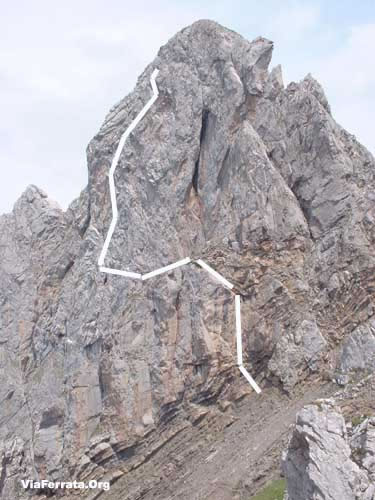
 Sur le topo la voie rouge
Passerelle Pont de singe Echelle Tyrolienne 0 0 0 0 Caractéristiques
Splendide panorama, longue, variée.
Payante: Frs. 4.-- pour les adultes, Frs. 2.-- enfants.Tous les jours de 9h00 à 18h00.
Astuces ViaFerrataPrends le pic-nic avec toi. Le panorama du sommet de la via ferreta se déguste à pleines dents et le restaurant accepte les pique-niqueurs! (prends une boisson... ils sont sympas...).
La via est entièrement à l'ombre. Une petite laine si le temps n'est pas très chaud...
Le Moléson est une super station!!! Après la via profite pour faire de la luge d'été, du dévale kart ou de la Trotine Herbe...
Les remontées mécaniques sont ouvertes dès 09h00. Vérifie qu'elles sont ouvertes si tu veux prendre le funiculaire pour rejoindre la via ferrata.A manger dans la région: la crème double de la Gruyère avec ses meringues.
Cotation
Physique 2 Gaz 3 Type Haute-Montagne: 2 Technique 1 Evaluation Difficile Information
Office du Tourisme de Moléson Gruyère.
Longueur et AltitudeLongueur: 650 m
Dénivellation: 372 mètres
Départ: 1'630m
Coordonnée GPS
N 46'33'363
E 007'33'363
Alt. 1'522 m.Période
Du printemps à l'automne.
Horaire
Marche d’approche depuis l'arrivée du funiculaire: 20 minutes
Via Ferrata: 2 heures
Marche de retour: retour en télécabine depuis le sommet du Moléson. A pieds, 1h30Par la routeA12 Vevey - Fribourg-Berne, Sortie Autoroute: Bulle
A la sortie de l'autoroute, prends la première sortie du rondpoint (à côté de la station d'essence) en direction du Moléson - Gstaad
Puis "Le Moléson"Par le TrainJusqu'à Bulle et ensuite en Bus ou en train jusqu'à Gruyère. Contacte les CFF, pour les horaires et le tarif.
Par Montreux: Montbovon jusqu'à Gruyères Gare, puis en Bus jusqu'à Moléson-sur-Gruyères.Contacte les CFF , pour les horaires et le tarif.
AccèsC'est du tout simple. A Moléson, parque vers le départ du Funiculaire.
Depuis le parking de Moléson-sur-Gruyères, pars sur Plan-Francey à pied (1h15) ou en funiculaire (7 min, départ toutes les 20 min, à...h00,...h20,...h40). (Frs 14.-- aller/retour)
A Plan Francey, tu peux louer du matériel via ferrata
De Plan-Francey suis les panneaux Via Ferrata pendant env 20 min et tu atteins le pied de la face. Il s'agit de la via ferrata qui se trouve sur la gauche, le long de l'arrête et non pas celle qui est à droite dans la face.Via Ferrata
Contrairement à sa voisine de droite qui monte dans la face, cette via ferrata débute fort et se termine plus relax.
Après avoir passé dans une charmante traversée dans les rochers, tu vas rejoindre une partie plus aérienne et franchement vertigineuse et très soutenue pour les bras. Là, tu as une simple équation: Gaz + Physique = pour les viaferratistes en forme.
Cependant, tu trouves un échappatoire pour l'éviter.La deuxième partie est un imbroglio entre tronçon dans l'herbe (où la boue) et de via ferrata.
Les chutes de pierres sont nombreuses, fais très attention.
Cette version est plus facile que sa voisine et peut convenir à des débutants, pour autant que tu prends l'échappatoire et que le gaz n'effraie pas trop.
A choisir, si tu es en bonne condition et que tu as l'expérience des via ferrata, sans soeur cadette de gauche est plus "sexy".Retour
Depuis le sommet, tu redescends à pied par Tsuatsaux (2h30 jusqu'au parking), par le Gros-Plané (1h45 jusqu'au parking) ou en téléphérique (4 min jusqu'à la gare amont).
Où dormirContacte l'Office du Tourisme. Le Moléson est une station hyper sympa.
Olivier Buchs Youtube
Photos
-


