ferrata
-
515e Via Ferrata the Pilier, Moléson, Gruyère, Fribourg, Switzerland
Via Ferrata the Pilier Moléson, Gruyère, Fribourg

Footbridge Monkey Bridge Ladder Zipline 0 0 0 0 Features
Splendid panorama, long, varied.
It costs 4.-- Frs. for adults and 2.-- Frs. for children. ViaFerrata Tips and Tricks
Take a picnic with you. The panorama at the top of the via ferrata is truly something to be savoured and the restaurant accepts picknickers! (buy a drink... they are nice...).
The via is entirely in the shade. Bring an extra layer in case the weather is not very warm...
The Moléson is a superb resort!!! After the via you can enjoy summer sledding,devalkarting, or grass-scootering.The lifts are open at 9h00. Make sure they are open if you want to take the funicular to get to the via ferrata.
What to eat in this region: the double Gruyère cream with the Gruyère meringues.
Grade
Strength 2 Dizziness 3 Type High Mountain: 2 Technics 1 Evaluation Difficult Information
Tourism Office Moléson Gruyère.
 Length and Altitude
Length: 650 m
Altitude gain: 372 mètres
Start: 1'630m
GPS Coordinates
N 46'33'363
E 007'33'363
Alt. 1'522 m.Time of Year
From spring to autumn.
Timing
Approach from the top of the funicular: 20 minutes
Via Ferrata: 2 hours
Way back: way back with the lifts from the lifts from the summit of Moléson. On foot, 1h30. By Car
A12 Vevey- Fribourg-Bern, Highway exit: Bulle
When you exit the highway, take the first exit of the roundabout (next to the gas station) towards Moléson-Gstaad
Next go to "Le Moléson" By Train
To Bulle and then by bus or train to Gruyère.
Via Montreux: Montbovon to the Gruyères train station, then by bus to Moléson-sur-Gruyères.Contact the SBB, for schedules and fares.

 Access
It's very simple. In Moléson, park near the bottom of the funicular.
From the Moléson-sur-Gruyères parking lot, go towards Plan-Francey on foot (1h15) or with the funicular (7 min, leaving every 20 min, at...h00,...h20,...h40). (14.-- Frs. there and back).
In Plan Francey you can rent via ferrata equipment.
In Plan-Francey follow the Via Ferrata signs for about 20 min and you will get to the base of the wall. The via ferrata described in this article is found on the left along the ridge, and is not the one that is on the right in the rock face.
Via Ferrata
Unlike its neighbour to the right which climbs into the rock face, this via ferrata starts strong and finishes in a more relaxed manner.
After a charming traverse of the rock, you arrive to a section that is more exposed and frankly vertiginous and very demanding for your arms. Here, you have a simple equation: Void + Strenuous = for fit via ferraters.
Nevertheless, there is an escape route to avoid this section.The second part is a mish-mash between a grassy (or muddy) section and via ferrata.
Falling rocks are common, be very careful.This version is easier than its neighbour and can be done by beginners, so long as you take the escape route and so long as the void doesn't scare you too much.
It's up to you, if you are in shape and you have experience with via ferratas, its little sister on the left is the "sexier" choice.Way Back
From the top, you can go down on foot via Tsuatsaux (2h30 to the parking lot), via Gros-Plané (1h45 to the parking lot) or with the lifts (4 min to the upper train station).
 Where to Spend the Night
Contact the Tourism Office. The Moléson is a really nice resort.
Olivier Buchs Youtube
Media
-
516e Via Ferrata of the Belvedère, Nax, Valais, Switzerland
Via Ferrata of the Belvédère, Nax, Valais
 Topo Visinant.ch
 Footbridge Monkey Bridge Ladder Zipline 0 2 (but tiny) 0 0 Features
This via ferrata is ideal for beginners and an introduction to via ferratas. The escape route has been canceled. If you stat it, you must finish it till the end
Open all year.
 ViaFerrata Tips and Tricks
Bring a picnic for the end of the via, you can climb up on the gazebo (the old end of the via) to make the most of the view. Nax is a nice village.
Grade
Strength 1 Dizziness 2 Type Plaine:2 Technics 2 Evaluation Initiation Information
Tourism office of Nax
 Length and Altitude
Length: 450 m
Altitude gain: 220 m
Start: 1'000m
GPS Coordinates
From the beginning of the via:
N 46.13.454
E 007.25.166
Altitude: 995 m.Time of Year
Open all year.
Timing
Aprroach on foot from the parking lot: 5 minutes
Via Ferrata: 1h
Way back: about 25 min back to the parking lot By Car
From the highway from Martigny take the second exit in Sion (Hospital). Go towards Bramois.
In Bramois cross the bridge over the river and go towards Nax. The via is found about 5km from Bramois. There is a parking lot on the left side of the road in a hairpin and a sign points you to the via ferrata.
 By Train
Take the train to Sion. Then the bus to Nax. Contact the SBB for schedules and fares.

 Access
From the parking lot follow the small trail in the forest. You will see the sign that welcomes you to the via. Walk a couple minutes more and you arrive at the beginning of the via ferrata.
Via Ferrata
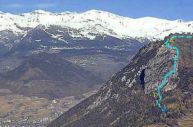
In front of you is the impressive Belvédère cliff: 240 meters of rock, sometimes perfectly vertical
Rules to obey: Never stray from the markings, the numerous ledges are interspersed with projections that are sometimes insurmountable, and the ground can be slippery. You must have the minimum required equipment, that is a helmet (the rock is friable), harness, Y shaped lanyard with a progressive tearing energy absorber, auto-locking carabiners, a rope for children and beginners
The first part of the route is composed of big walls, connected by sequences of ledges and projections. You will cross a small rope bridge (about 3 m), the exit is a bit technical and physical, but nothing too demonic. What's more, there is some void.
You then arrive to a second rope bridge. Make the most of it as the via ferrata ends in a few minutes.
Way Back
Oh! You must go up to the gazebo for the view. Then, take the trail that goes down. The trail is good overall, a bit steep in some places and rock&roll if its humid and rainy.
 Where to Spend the Night
ViaFerrata.com Youtube
Photos
-
519 Via Ferrata Allmenalp Kandersteg Berne Suisse
Via Ferrata Allmenalp, Kandersteg, Berne
Passerelles Pont Népalais Echelles Tyroliennes 2 30 m 4 2 Caractéristiques
A ne pas mettre en toutes les mains. Très technique.
Des clous/pieux à la place des traditionnelles marches en métal. Beaucoup de contacts avec le rocher. Les pieux peuvent comporter un certain risque. Faire très attention si tu désires prendre des enfants.
Nouvelle variante "Freude herrscht".La nouvelle variante "Freude herrscht" est classée hyper difficile. Cette variante est très difficile et ne convient donc qu'à des grimpeurs expérimentés et sans vertige.
 Info ViaFerrata
Attention à la météo! Le temps change très vite à Kandersteg. Si la pluie menace, n'y va pas. Le torrent peu gonfler très rapidement et tu seras coincé dans la via! Nous sommes restés 2 heures à attendre que l'orage passe avec des chutes de pierres nombreuses.
Des chaussures de marche avec une excellente semelle sont obligatoires!
Cotation
Physique 4 Gaz 4 Type Haute-Montagne: 3 Technique 3 Evaluation Extrêmement Difficile Information
Office du Tourisme de Kandersteg
 Longueur et Altitude
Dénivellation: 350 mètres
Altitude Départ: 1'176 m
Période
Juin à Octobre (selon les remontées mécaniques)
Horaire
Marche d’approche: 20 minutes
Via Ferrata: 3h00
Marche de retour: par le Télécabine ou 2h00 à pieds. Par la route
Passe Berne et prends la direction de Thun. Ensuite monte vers Kandersteg.
 Par le Train
Jusqu'à Thun et ensuite en Bus. Contacte les CFF, pour les horaires et le tarif.

 Accès
AccèsDe la gare de Kandersteg sur le chemin de randonnée vers la vallée. Quand l'Allmibach se jette dans la Kander, prendre à droite du torrent en direction du nord jusqu'au point de départ à env. 1250 m.
De la station inférieure du téléphérique d'Allmenalp, après une ferme, tu traverses la rivière sur un pont.
Du départ des remontées mécaniques, suis le chemin Bleu et Blanc (Klettersteig). Le parking est gratuit.
Via Ferrata
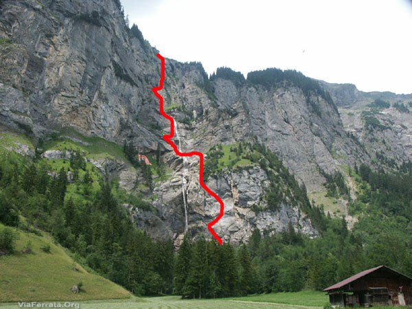
Le parcours longe la cascade de l'Allmibach est c'est très romantique. Le tout débute par 3 échelles et une montée vertigineuse. Au lieu des traditionnelles marches, tu grimpes sur des clous/pieux.
C’est assez différent des via ferrata normales et assez peu commode. Ca glisse et il te faut avoir d’excellentes chaussures (baskettes, tongues interdites).
Tu passes sur la cascade via une longue passerelle. Là, un sentier te conduit à la partie suivante.
Une échelle torsadée te fera faire un 180 degrés et tu découvres la cascade sous un nouvel angle. C’est très aérien et surtout tu es en contact avec le rocher le long d’une arrête.
Si tu es accompagné d'un guide, tu pourras faire la tyrolienne (fermée à clé, d’où le guide)
Tu continues la montée et traverses une passerelle en bois et tu as le choix d’une tyrolienne ou un pont de singe hyper gaz ! La montée à la tyrolienne, par temps humide, est une épreuve. Les marches installées n’ont pas de profils, de vraies savonnettes. Prudence!
Le passage du pont népalais est un moment intense ! La dernière partie surplombe toute la via et est plus facile.Retour
Si tu arrives avant les 18h00, le télécabine est à disposition. Le restaurant à côté de la télécabine est super sympa et les tartes sont excellentes.
Si tu rappliques après les 18h00, prépare-toi à 2 heures de descente pas toujours bien marquée. Suis la route pendant 30 minutes et ensuite les panneaux jaunes pour te ramenezrvers la station. Si tu te perds, dis-toi que n'est pas le premier ni le dernier!
 Où dormir
Voir avec l'Office du Tourisme. Interlaken est très sympa et il y a plusieurs campings.
par Josh Turner Youtube
Photos
-
519e Via Ferrata Allmenalp, Kandersteg, Bern, Switzerland
Via Ferrata Allmenalp, Kandersteg, Bern

Footbridges Monkey Bridge Ladders Ziplines 2 30 m 4 2 Features
Not for everyone. Very technical.
There are stakes instead of the traditional metal steps. Lots of contact with the rock. The stakes can present a certain risk. Be very careful if you want to bring children.
 ViaFerrata Tips and Tricks
Pay attention to the weather! It changes very quickly in Kandersteg. If rain is imminent, don't go. The stream can swell very quickly and you will be stuck in the via! We once stayed 2 hours waiting for a thunderstorm to pass and there were many falling rocks.
Hiking shoes with an excellent sole are mandatory!
Grade
Strength 4 Dizziness 4 Type High-Mountain: 3 Technics 3 Evaluation Extreme Information
Office du TourismeKandersteg
 Length and Altitude
Altitude gain: 350 m
Start altitude: 1'176 m
Time of Year
June to October (when the lifts are open)
Timing
Approach: 20 minutes
Via Ferrata: 3h00
Way back: with the lifts or 2h on foot. By Car
Go past Bern and continue towards Thun. Then go up towards Kandersteg.
 By Train
Go to Thun and then take the bus. Contact the SBB for schedules and fares.

 Access
From the Kandersteg train station take the hiking trail that goes towards the valley. Where the Allmibach flows into the Kander, head north to the right of the stream until you get to the starting point at about 1250 m.
From the lower lift station of the Allmenalp, after a farm, cross the river on a bridge.
From the bottom of the lifts, follow the blue and white trail (Klettersteig). Parking is free.
Via Ferrata
The route follows the Allmibach waterfall and the scene is very romantic. Everything starts off with three ladders and a vertiginous climb. Instead of going up traditional steps, you climb on stakes.
It's pretty different from the usual via ferratas and a bit awkward. It's slippery and you must have adequate footwear (tennis shoes and flip flops are prohibited).
You cross over the waterfall via a long footbridge. Here, a path takes you to the next section.
A twisting ladder will make you rotate 180 degrees and you will gain a new perspective on the waterfall. It's very vertiginous, but you remain in contact with the rock along a ridge.
If you are with a guide you can go on the zipline (it is locked, hence, you must have a guide)
You keep climbing and traverse a wooden footbridge and you then have the choice between a zipline or a very vertiginous rope bridge! Going up to the zipline in wet weather is a real challenge. The steps that were put in place have no profile, they are real soapstones. Be careful!
Crossing the monkey bridge is moment of pure intensity! The last part overlooks the entire via and is easier.
Way Back
If you make it before 18h00, the lifts are still open. The restaurant next to the lifts is really nice and the pies are excellent.
If you arrive after 18h00, be prepared for 2 hours of not always well-marked downhill. To get back to the resort, follow the road for 30 minutes and then the yellow signs. If you get lost, tell yourself that you are neither the first nor the last!
 Where to Spend the Night
Check with the Tourism Office. Interlaken is really nice and there are several campgrounds.
par Josh Turner Youtube
Media


